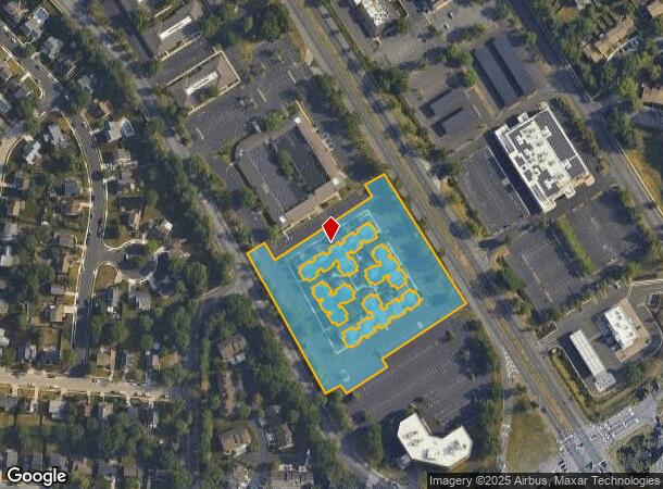
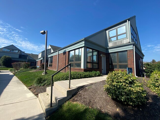
Property Record
651 Route 73 N, Marlton, NJ 08053


NEARBY LISTINGS FOR SALE OR LEASE
Property Detail
651 Route 73 N
Philadelphia-Camden-Wilmington, PA-NJ-DE-MD
Pavilions/Greentree
13-00003-34-00004
ADDITIONAL LOTS: CONDO OWNERS/FACILITY NAME: COMMON ELEMENT
Taxexempt
Burlington
X
New Jersey
34005C0243F
4
0
4.19 AC
2025
South Burlington County
704005
Philadelphia
1,384 SF
DEMOGRAPHICS near 651 Route 73 N
1 Mile
3 Mile
5 Mile
2024 Total Population
9,942
78,869
193,584
2029 Population
10,187
79,706
195,560
Pop Growth 2024-2029
+ 2.46%
+ 1.06%
+ 1.02%
Average Age
42
43
42
2024 Total Households
4,118
31,014
76,193
HH Growth 2024-2029
+ 2.14%
+ 1.09%
+ 1.02%
Median Household Inc
$95,399
$115,523
$110,703
Avg Household Size
2.40
2.50
2.50
2024 Avg HH Vehicles
2.00
2.00
2.00
Median Home Value
$291,540
$338,456
$339,822
Median Year Built
1977
1980
1977
Nearby Places
Map Layers
Map Styles
 Street
 Aerial
- Restaurants
- Banks
- Shops
- Fitness
- Groceries
SALE & LEASE HISTORY
LISTING DATE
SALE/LEASE

Oct 22, 2021
For Lease
Nearby Properties
Address
Land Use
TOTAL SIZE
Lot Size
Zoning
Address
Land Use
TOTAL SIZE
Lot Size
Zoning
1,896 SF
93.79 AC
LD
Address
Land Use
TOTAL SIZE
Lot Size
Zoning
23.82 AC
Address
Land Use
TOTAL SIZE
Lot Size
Zoning
270,246 SF
0.71 AC
RA
Address
Land Use
TOTAL SIZE
Lot Size
Zoning
25,536 SF
18.71 AC
Address
Land Use
TOTAL SIZE
Lot Size
Zoning
44.80 AC
C-1
Address
Land Use
TOTAL SIZE
Lot Size
Zoning
5 AC
C-1
Address
Land Use
TOTAL SIZE
Lot Size
Zoning
52.30 AC
MD
Address
Land Use
TOTAL SIZE
Lot Size
Zoning
114,852 SF
12.73 AC
GB2
Address
Land Use
TOTAL SIZE
Lot Size
Zoning
57.50 AC
Address
Land Use
TOTAL SIZE
Lot Size
Zoning
43.20 AC
Address
Land Use
TOTAL SIZE
Lot Size
Zoning
999,999,999 SF
21.10 AC
Address
Land Use
TOTAL SIZE
Lot Size
Zoning
Address
Land Use
TOTAL SIZE
Lot Size
Zoning
122,264 SF
5 AC
RR
Address
Land Use
TOTAL SIZE
Lot Size
Zoning
42.80 AC
MF
Address
Land Use
TOTAL SIZE
Lot Size
Zoning
11.29 AC
Address
Land Use
TOTAL SIZE
Lot Size
Zoning
15.10 AC
Address
Land Use
TOTAL SIZE
Lot Size
Zoning
25.28 AC
C-1
Address
Land Use
TOTAL SIZE
Lot Size
Zoning
23.43 AC
INS
Address
Land Use
TOTAL SIZE
Lot Size
Zoning
2,264 SF
17.30 AC
C-1
Address
Land Use
TOTAL SIZE
Lot Size
Zoning
31.88 AC
MD
Address
Land Use
TOTAL SIZE
Lot Size
Zoning
84.19 AC
Address
Land Use
TOTAL SIZE
Lot Size
Zoning
11.73 AC
GB2
Address
Land Use
TOTAL SIZE
Lot Size
Zoning
77,224 SF
7.65 AC
RR
Address
Land Use
TOTAL SIZE
Lot Size
Zoning
10.38 AC
C-1
Address
Land Use
TOTAL SIZE
Lot Size
Zoning
1,416 SF
16.88 AC
C-1
Address
Land Use
TOTAL SIZE
Lot Size
Zoning
165,328 SF
8.82 AC
GB2
Address
Land Use
TOTAL SIZE
Lot Size
Zoning
12.62 AC
C-1
Address
Land Use
TOTAL SIZE
Lot Size
Zoning
23.57 AC
Address
Land Use
TOTAL SIZE
Lot Size
Zoning
5,484 SF
12.90 AC
C-1
Address
Land Use
TOTAL SIZE
Lot Size
Zoning
13.15 AC
The World's #1 Commercial Real Estate Marketplace
Connect with us
© 2025 CoStar Group
The information above has been obtained from sources believed reliable. While we do not doubt its accuracy we have not verified it and make no guarantee, warranty or representation about it. It is your responsibility to independently confirm its accuracy and completeness. Any projections, opinions, assumptions, or estimates used are for example only and do not represent the current or future performance of the property. The value of this transaction to you depends on tax and other factors which should be evaluated by your tax, financial, and legal advisors. You and your advisors should conduct a careful, independent investigation of the property to determine to your satisfaction the suitability of the property for your needs.